
How to Find the Next Exit From Your Location
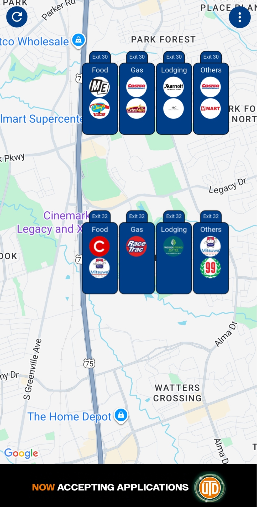
You are on the interstate, the tank is lower than you'd like, and the question is simple: what exit am I at, how far is the next one, and does it have gas? The road itself answers most of that if you know where to look, and a phone can fill in the rest. Here is what works, in the order you'd use it at 70 mph.
1. Read the exit number as a distance
In most US states, interstate exits are numbered by milepost: Exit 42 sits at or near mile 42, counted from where the highway enters the state (from the south or west end). That makes the exit number a distance you can do math with. If you just passed Exit 42 and the next sign says Exit 51, the next exit is about nine miles ahead. If you know your destination is Exit 120, you have 78 miles to go.
Letters mean several exits share one mile: 42A, 42B and 42C are all within mile 42, usually in order along your direction of travel. A handful of states and some older toll roads still number exits in sequence (1, 2, 3) with no relation to miles; there, the number tells you the order of exits but not the distance between them.
2. Use the mileposts between exits
The small green markers on the shoulder are mileposts, placed every mile on most interstates and more often in some states. They are the quickest way to answer "what exit am I near" when no exit sign is in view: read the milepost, and in a mileage-numbered state the next exit number will be close to it or above it. A milepost of 118 with a known Exit 120 ahead means roughly two miles to go.
Mileposts count up in one direction (northbound and eastbound) and down in the other, so they also tell you which way you are heading if you've lost track after a detour.
3. Watch for the signs that announce an exit
- Advance guide signs (green) appear ahead of an exit, typically two miles and one mile out in rural areas and a half mile or less in cities, with the exit number and the roads it serves.
- Service signs (blue) list gas, food, lodging and camping available at the coming exit, often with brand logos. If there is no blue sign, expect no services.
- "Next services" and "No services" signs warn you when the next fuel is far: a sign reading "Next Services 42 Miles" is the one to take seriously on a low tank.
- Rest area signs (blue) show distance to the next rest area, which has parking and restrooms but usually no fuel.
4. Let a navigation app count down the exit
Google Maps, Apple Maps and Waze all show the next maneuver while you are navigating a route, and on an interstate that is usually the next exit you need, with its distance and exit number. Two limits are worth knowing. First, they show the next exit on your route, not every exit; if you want to stop early, you have to search for a gas station or restaurant and let the app re-route. Second, without an active route, most apps show your position on the map but not a list of what is coming up.
A search like "gas station" inside the app sorts results by distance as the crow flies, which on a divided highway can point you to a station on the wrong side of the median or down an exit you have already passed. Check which exit the result is actually behind before you commit a lane change.
5. Know what your phone can and can't tell you
A phone knows its position to within several meters, which is enough to place you on the map but not always enough to say which of two parallel roads you are on, or which direction you are moving when you are stopped in traffic. Working out "the next exit ahead of me on this road" from that single point is a surprisingly hard problem; the guide Why "What's Ahead?" Is a Hard Question explains why. The practical consequence: give any app a few seconds of steady driving before trusting what it says is next.
6. Or use an app built for exactly this
Exit Explorer uses your location to find upcoming highway exits and the businesses near them, grouped into gas, food, lodging and other services, with ratings and distances, so you can decide where to stop before the sign goes by. It is free on both stores:


Quick answers
What exit am I on right now?
Look for the last green exit sign you passed, or read the nearest milepost: in a mileage-numbered state the exit number matches the milepost. A navigation app with an active route shows the next exit number at the top of the screen.
How far is the next exit from my location?
Subtract the milepost you just passed from the next exit's number. The first advance sign for an exit appears one to two miles before it on rural interstates.
How do I find the next exit with a gas station?
Watch for the blue service sign before each exit; a fuel logo on it means a station at that exit. If you need to plan further ahead, search in a map app and check which exit each result is behind, or use an app that lists services by exit.
Why do exit numbers sometimes jump?
Because they are mileposts, not a count. Exit 51 after Exit 42 means nine miles with no exit, which is common in rural stretches.